16,896 bytes. 148 x 455 pixels.
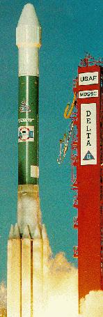
| astronautix.com | Delta 7925 |
|
| Delta 7925 no. 205 - Delta 7925 no. 205 - COSPAR 1991-037 16,896 bytes. 148 x 455 pixels. |
Launches: 74. Failures: 2. Success Rate: 97.30% pct. First Launch Date: 26 November 1990. Last Launch Date: 16 July 2000. LEO Payload: 5,089 kg. to: 185 km Orbit. Payload: 1,818 kg. to a: Geosynchronous transfer trajectory. Liftoff Thrust: 317,000 kgf. Total Mass: 231,870 kg. Core Diameter: 2.4 m. Total Length: 38.1 m. Launch Price $: 60.00 million. in 1999 price dollars.
Global Positioning System. Spacecraft engaged in practical applications and uses of space technology such as weather or communication (US Cat C).
NATO communications; 18 deg W. Spacecraft engaged in practical applications and uses of space technology such as weather or communication (US Cat C).
Commercial business communications; stationed at 101 deg W. C, Ku band communications satellite.
Stationed at 139 deg W. Spacecraft engaged in research and exploration of the upper atmosphere or outer space (US Cat B).
Global Positioning System. Spacecraft engaged in research and exploration of the upper atmosphere or outer space (US Cat B).
Test flight of DOD sensors; Low Altitude Satellite Experiment. Spacecraft engaged in research and exploration of the upper atmosphere or outer space (US Cat B).
Global Positioning System. Spacecraft engaged in research and exploration of the upper atmosphere or outer space (US Cat B).
Global Positioning System. Spacecraft engaged in research and exploration of the upper atmosphere or outer space (US Cat B).
Stationed at 118 deg E.
Spacecraft engaged in practical applications and uses of space technology such as weather or communication (US Cat C).
Stationed at 135 deg W.
Spacecraft engaged in practical applications and uses of space technology such as weather or communication (US Cat C).
Stationed at 33.5 deg E. Communication satellite. Longitude 33.5 deg E. Delta II flight no 212.
Global Positioning System. Spacecraft engaged in practical applications and uses of space technology such as weather or communication (US Cat C).
Global Positioning System. Spacecraft engaged in practical applications and uses of space technology such as weather or communication (US Cat C).
Global Positioning System. Spacecraft engaged in practical applications and uses of space technology such as weather or communication (US Cat C).
 | Delta 7925 Credit: Boeing. 21,299 bytes. 367 x 387 pixels. |
Small Expendable-tether Deployer System.
Global Positioning System. Spacecraft engaged in practical applications and uses of space technology such as weather or communication (US Cat C).
Global Positioning System. Spacecraft engaged in practical applications and uses of space technology such as weather or communication (US Cat C).
Global Positioning SYstem. Spacecraft engaged in practical applications and uses of space technology such as weather or communication (US Cat C).
Global Positioning System. Spacecraft engaged in practical applications and uses of space technology such as weather or communication (US Cat C).
NATO encrypted communications relay. Spacecraft engaged in practical applications and uses of space technology such as weather or communication (US Cat C).
Stationed at 133 deg W; replaced Galaxy 1. Space craft engaged in investigation of spaceflight techniques and technology (US Cat A).
Final element of initial GPS constellation. Spacecraft engaged in practical applications and uses of space technology such as weather or communication (US Cat C).
Solar wind research in L-1 halo orbit; part of International Solar Terrestrial Physics program. 221 day orbit.
15 Ku-band transponders; boosted into geosynch orbit by satellite thrusters following Delta failure that left satellite in LEO; unplanned use of satellite propellant cut usable satellite lifetime by approx. 50 percent. Stationed at 116.0 deg E. Stage 1 SRM failure
Test satellite for NASA's Deep Space Network.
Earth imaging with synthetic aperture radar.
X-ray Timing Explorer; X-ray astronomy.
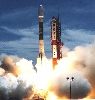
 | Delta 2 liftoff Credit: NASA. 27,075 bytes. 318 x 459 pixels. |
Near Earth Asteroid Rendezvous (NEAR) mission was the first of NASA's Discovery missions, a series of small-scale spacecraft designed to proceed from development to flight in under three years for a cost of less than $150 million. The spacecraft's mission was to rendezvous with and achieve orbit around the asteroid Eros in January, 1999, and study the asteroid for one year. Prior to its encounter with Eros NEAR flew within 1200 km of the C-class asteroid Mathilde on 27 June 1997. It then flew by the Earth on 23 January 1998. A problem caused an abort of the first encounter burn and the mission had to be rescoped for a later encounter. NEAR finally entered orbit around Eros on February 14, 2000. Orbit insertion was at 15:34 GMT into a 323 x 370 km initial orbit with a period of 27 days. The renamed NEAR-Shoemaker probe moved into a 100 x 200 km orbit around Eros on April 2 at 0200 GMT. NEAR returned spectacular detailed pictures of the surface over the next several months. Studies were made of the asteroid's size, shape, mass, magnetic field, composition, and surface and internal structure. Periapsis of the orbit would be as low as 24 km above the surface of the asteroid during the final days of the mission.
HEO. Fields and particles, auroral studies; part of International Solar Terrestrial Physics program.
MEO.
LEO. Midcourse Space eXperiment; missile detection technology tests; also used for auroral and atmospheric studies
Geostationary at 123.0W.
En route Mars
En route Mars
Plane 4. Ascending node 262.4 degrees.
Plane 4. Ascending node 262.5 degrees.
Plane 4. Ascending node 262.5 degrees.
Plane 4. Ascending node 262.5 degrees.
Plane 4. Ascending node 262.5 degrees.
Geosynchronous. Stationed over 0.8W
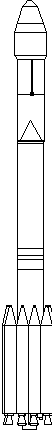 | Delta 2 Credit: © Mark Wade. 1,389 bytes. 52 x 432 pixels. |
Plane 6. Ascending node 310.4 degrees. Failed in low orbit.
Plane 6. Ascending node 325.8 degrees.
Plane 6. Ascending node 325.8 degrees.
Plane 6. Ascending node 325.8 degrees.
Plane 2. Ascending node 199.3 degrees. Should be 24905, failed.
Plane 2. Ascending node 199.4 degrees.
Plane 2. Ascending node 199.3 degrees.
Plane 2. Ascending node 199.4 degrees.
Plane 2. Ascending node 199.4 degrees.
Earth-Sun L1 point
Plane 4. Ascending node 262.6 degrees.
Plane 4. Ascending node 262.5 degrees.
Plane 4. Ascending node 262.5 degrees.
Plane 4. Ascending node 262.4 degrees.
Plane 4. Ascending node 262.4 degrees.
Plane 6. Ascending node 325.8 degrees.
Plane 6. Ascending node 325.8 degrees.
Plane 6. Ascending node 325.8 degrees.
Plane 6. Ascending node 325.6 degrees.
Plane 6. Ascending node 325.8 degrees.
Plane 2. Ascending node 199.4 degrees.
Plane 2. Ascending node 199.4 degrees. Should be 25105.
Plane 2. Ascending node 199.4 degrees.
Plane 2. Ascending node 199.4 degrees.
Plane 2. Ascending node 199.4 degrees.
 | Delta LV - Delta LV Solid Motor Separation Credit: Boeing. 13,069 bytes. 236 x 318 pixels. |
Plane 1. Ascending node 43.6 degrees.
Plane 1. Ascending node 42.4 degrees.
Plane 1. Ascending node 43.8 degrees.
Plane 1. Ascending node 43.9 degrees.
Plane 5. Ascending node 294.1 degrees.
Plane 5. Ascending node 294 degrees.
Plane 5. Ascending node 294.2 degrees.
Plane 5. Ascending node 294.2 degrees.
Plane 5. Ascending node 294.2 degrees.
Plane 3. Ascending node 230.9 degrees.
Plane 3. Ascending node 230.9 degrees.
Plane 3. Ascending node 230.9 degrees.
Plane 3. Ascending node 230.9 degrees.
Plane 3. Ascending node 230.9 degrees.
Plane 2. Ascending node 88.0 degrees.
Plane 2. Ascending node 90.2 degrees.
Plane 2. Ascending node 90.4 degrees.
Plane 2. Ascending node 88.9 degrees.
Plane 1. Ascending node 167.8 degrees.
Plane 1. Ascending node 167.8 degrees.
Plane 1. Ascending node 167.8 degrees.
Plane 1. Ascending node 167.8 degrees.
Plane 1. Ascending node 167.7 degrees. Not in service.
The spacecraft was delivered to its final orbit in a complex series of five engine burns by three rocket stages. The Delta's second stage demonstrated its restart capability in 4 burns: Burn 1 placed the rocket and payload into a low circular orbit; Burn 2 raised the apogee to 1400 km; Burn 3 circularised the orbit at 1400 km. The second stage then separated, and Burn 4 lowered the spent stage's perigee to a low altitude to ensure the stage would decay quickly and not add to the space junk already on orbit. Stage 3 burned once to place the payload and its kick motor into a high 1400 km perigee geosynchronous transfer orbit. The Stage 4 Star 30 apogee kick motor circularised the spacecraft's orbit at geostationary altitude. Geostationary at 0.8 degrees W.
Plane 6. Ascending node 325.6 degrees. Not in service.
Plane 6. Ascending node 325.7 degrees.
Plane 6. Ascending node 325.7 degrees.
Plane 6. Ascending node 316.3 degrees. Failed in low orbit.
Plane 6. Ascending node 325.4 degrees. Not in service.
Following separation of the third stage and the primary Deep Space 1 payload, the Delta second stage manoeuvred from its 185 km parking orbit to a 174 km x 2744 km x 28.5 degree orbit. It then released the SEDSAT micro-satellite, built by the Huntsville, Alabama chapter of SEDS (the Students for the Exploration and Development of Space). SEDSAT has two amateur radio transponders and an earth imaging camera.
The primary mission of Deep Space 1 probe was to test new technology for future interplanetary spacecraft, the main experiment being an ion propulsion engine using xenon propellant. It had an initial mass of 486.3 kg, including 81.5 kg of Xenon and 31.1 kg of hydrazine propellants. Deep Space 1 successfully started its ion engine on November 24 after an initial attempt failed after four minutes on November 10. From its initial solar orbit of 0.99 AU x 1.32 AU x 0.4 degree, Deep Space 1 was to fly past the 3 km diameter asteroid 1992 KD at its perihelion of 1.33 AU. An additional 2001 flyby of Comet 19P/Borrelly was also planned, by which time Deep Space 1 was to have manoeuvred to an orbit of 1.12 x 1.42 AU. Additional Details: Deep Space 1.
Plane 5. Ascending node 293.9 degrees. Raising orbit.
Plane 5. Ascending node 291.1 degrees. Parking orbit.
Plane 5. Ascending node 289.1 degrees. Parking orbit.
Plane 5. Ascending node 294.2 degrees.
Plane 5. Ascending node 294.1 degrees. Raising orbit.
BONUM-1 provided domestic Russian television service for Media Most, a Moscow media enterprise, broadcasting 50 channels to western Russia from a geostationary orbit at 36 degrees E. Mass was 1426 kg at launch, 800 kg of that propellant. BONUM-1 carried 8 Ku-band transponders. The Delta upper stage raised the initial 157 km x 189 km at 29.2 degree parking orbit to 159 km x 1304 km and then 1228 km x 1683 km at 26.7 degrees. A Thiokol Star 48B solid third stage boosted BONUM-1 to a 1285 x 36703 km x 19.5 degree geostationary transfer orbit, with the Thiokol Star 30 apogee kick motor placing the satellite in its final geostationary orbit. After separation of the spacecraft, the Delta made a final depletion burn to lower its orbit to 274 km x 1552 km x 25.6 degree to ensure it would quickly decay and burn up in the atmosphere. Geostationary at 35.9 degrees E.
The Mars Climate Orbiter was the second flight of the Mars Surveyor Program. The probe was to enter a 160 km x 38600 km polar orbit around Mars on September 23,1999, and use aerobraking to reach a 373 km x 437 km x 92.9 degree sun-synchronous mapping orbit by November 23 1999. While the Mars Orbit Insertion burn began as planned on September 23, 1999 at 08:50 GMT, no signal was received after the spacecraft went behind the planet. Subsequent investigation showed that the spacecraft had plunged deep into the Martian atmosphere, with its closest approach to Mars being 57 km. It was concluded that the spacecraft burnt up in the atmosphere. It was later found that cutbacks in tracking, combined with incorrect values in a look-up table imbedded deep in the spacecraft software (use of pounds force instead of newtons) were to blame. This failure led to a shake-up of NASA's 'faster, better, cheaper' approach to unmanned spaceflight. Additional Details: Mars Climate Orbiter.
The Mars Polar Lander was placed by the first burn of the second stage into a 157 x 245 km x 28.35 deg parking orbit. The second stage restarted at 20:55 GMT and shut down in a 226 x 740 km x 25.8 deg Earth orbit. The solid rocket third stage (a Star 48B with a Nutation Control System and a yo-yo despin device) then ignited and put the spacecraft into solar orbit, separating at 21:02 GMT. Mars Polar Lander was to land near the south pole of Mars on December 3, 1999, and conduct conduct a three month mission, trenching near its landing site and testing for the presense of frozen water and carbon dioxide. Attached were two Deep Space 2 Microprobes, penetrators which would impact the Martian surface separately from the lander and return data on subsurface conditions from widely spaced points.
When the spacecraft reached Mars on December 3, the lander separated from the cruise stage at 19:51 UTC and the two penetrators, Scott and Amundsen, were to separate about 20 seconds later. No further communications were ever received from the spacecraft. Landing had been expected at 20:01 UTC at 76.1S 195.3W, with the penetrators landing a few kilometres from each other at 75.0S 196.5W.
This failure resulted in a review and reassessment of NASA's 'faster, better, cheaper' approach to planetary missions.
Stardust was to fly within 100 km of comet 81P/Wild-2 in January 2004 and recover cometary material using an aerogel substance. A return capsule would land on a lake bed in Utah in January 2006, returning the material to earth. The launch went as planned. The second stage ignited at 21:08 GMT and its first burn put the vehicle into a 185 km x 185 km x 28 degree parking orbit at 21:14 GMT. The second stage second burn at 21:25 changed the orbit to planned values of 178 km x 7184 km x 28.5 degrees. The Star 37FM solid third stage ignited at 21:29 GMT and placed the spacecraft into a 2 year period solar orbit. The spacecraft separated at 21:31 GMT. Meanwhile, the Delta 266 second stage burned a third time on its own, until its propellants were depleted, entering a final orbit of 294 km x 6818 km x 22.5 degrees.
ARGOS was a USAF Space Test Program P91-1 technology satellite, equipped with an ion engine, ionosphere, x-ray, and dust detectors. Much delayed, it finally was placed into orbit on the eleventh (!) launch attempt.
Sunsat was built by students at Stellenbosch University, South Africa and carried a small imager and a message relay payload.
Denmark's Orsted gravity gradient stabilised satellite was to map the Earth's magnetic field. It was managed and operated by the Danish Meteorological Institute in Copenhagen. The satellite's prime contractor was CRI , Copenhagen.
The vehicle entered a 175 km x 706 km x 98.2 deg initial orbit. 57 minutes after launch the Delta stage burned again to circularize the orbit at 668 km x 698 km and Landsat 7 separated from the stage. The Delta stage then burned to depletion of its propellant, into a 184 km x 710 km x 107.5 deg orbit that would decay quickly. The Landsat 7 remote sensing satellite was to be operated by NASA/Goddard until October 2000, when operations would be transferred to the US Geological Survey.
The Delta 3-m payload fairing was successfully jettisoned and the Far Ultraviolet Spectroscopic Explorer was placed in a 754 km x 769 km x 25.0 degree initial orbit. After separation the Delta second stage then a depletion burn and was left in a 182 x 915 km x 19.1 degree orbit from which it would quickly decay out of orbit. Checkout of FUSE in orbit was proceeding well as of July 1.
Third GPS Block 2R satellite. SVN 46 replaced SVN 50 which had been damaged by rain on Pad 17 earlier while being prepared for launch earlier in the year.
These four Globalstar satellites completed the Globalstar initial constellation.
Imager for Magnetopause to Aurora Global Exploration was a MIDEX (mid-sized Explorer mission) developed by NASA-Goddard and the SWRI (Southwest Research Institute) of San Antonio, Texas. The spin-stabilised spacecraft carried a set of neutral atom and ultraviolet imagers, and antennae to study radio wavelength emissions from the magnetosphere plasma. The RPI radio plasma imager has four long wire antennae which will be deployed to a span of half a kilometre.
Navstar Block IIR GPS navigation satellite, GPS IIR-4 or SVN 51. Placed into an elliptical transfer orbit. The satellite's Thiokol Star 37 apogee motor was used to circularise the orbit at 20,000 km.