This page no longer updated from 31 October 2001. Latest version can be found at www.astronautix.com
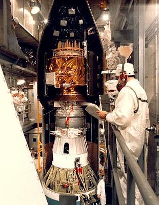 |
| GPS IIA in assembly - Credit: Hughes. 34,327 bytes. 310 x 400 pixels. |
|
Other Designations: Global Positioning System. Class: Navigation. Nation: United States. Agency: U.S. Air Force. Manufacturer: Rockwell Space Systems. GPS Block 2 is the Operational system, following the Demonstration system comprised of Block 1 spacecraft. The Block 2A are "Advanced" versions of this spacecraft. The complete constellation has 24 spacecraft in 6 high-altitude orbit planes. Spacecraft: 3-Axis stabilised, nadir pointing using reaction wheels. Dual solar arrays supply 710 watts (EOL). S-Band (SGLS) communications for control and telemetry. UHF cross-link between spacecraft. Hydrazine propulsion system. Payload: Two L-Band navigation signals at 1575.42 MHz (L1) and 1227.60 MHz (L2). Each spacecraft carries 2 rubidium and 2 caesium clocks. Also carry nuclear detonation detection sensors.
Financial/Operational:
Launches scheduled for Proton, Atlas, and Delta. Satellite costs: Block I $ 20 million each, Block II $ 50 million, Block IIA $ 40 million.
SpecificationDesign Life: 7.5 years. Total Mass: 1,665 kg.
GPS Block 2 and 2A Chronology
14 February 1989
USA 35; Navstar BII-01 (GPS) Program: Navstar. Launch Site: Cape Canaveral . Launch Vehicle: Delta 6925. Mass: 1,665 kg. Perigee: 20,087 km. Apogee: 20,276 km. Inclination: 55.1 deg. Second generation Global Positioning System. Spacecraft engaged in practical applications and uses of space technology such as weather or communication (US Cat C).
10 June 1989
USA 38; Navstar BII-02 (GPS) Program: Navstar. Launch Site: Cape Canaveral . Launch Vehicle: Delta 6925. Mass: 1,665 kg. Perigee: 19,849 km. Apogee: 20,514 km. Inclination: 54.8 deg. Global Positioning System. Spacecraft engaged in practical applications and uses of space technology such as weather or communication (US Cat C).
18 August 1989
USA 42; Navstar BII-03 (GPS) Program: Navstar. Launch Site: Cape Canaveral . Launch Vehicle: Delta 6925. Mass: 1,665 kg. Perigee: 20,164 km. Apogee: 20,201 km. Inclination: 54.9 deg. Global Positioning System. Spent boosters, spent maneuvering stages, shrouds and other non-functional objects (US Cat D).
21 October 1989
USA 47; Navstar BII-04 (GPS) Program: Navstar. Launch Site: Cape Canaveral . Launch Vehicle: Delta 6925. Mass: 1,665 kg. Perigee: 20,166 km. Apogee: 20,198 km. Inclination: 53.7 deg. Global Positioning System. Spacecraft engaged in practical applications and uses of space technology such as weather or communication (US Cat C).
11 December 1989
USA 49; Navstar BII-05 (GPS) Program: Navstar. Launch Site: Cape Canaveral . Launch Vehicle: Delta 6925. Mass: 1,665 kg. Perigee: 19,992 km. Apogee: 20,371 km. Inclination: 55.4 deg. Global Positioning System. Spacecraft engaged in research and exploration of the upper atmosphere or outer space (US Cat B).
24 January 1990
USA 50; Navstar BII-06 (GPS) Program: Navstar. Launch Site: Cape Canaveral . Launch Vehicle: Delta 6925. Mass: 1,665 kg. Perigee: 20,045 km. Apogee: 20,319 km. Inclination: 54.1 deg. Global Positioning System. Spent boosters, spent maneuvering stages, shrouds and other non-functional objects (US Cat D).
26 March 1990
USA 54; Navstar BII-07 (GPS) Program: Navstar. Launch Site: Cape Canaveral . Launch Vehicle: Delta 6925. Mass: 1,665 kg. Perigee: 20,073 km. Apogee: 20,290 km. Inclination: 55.1 deg. Global Positioning System. Spacecraft engaged in research and exploration of the upper atmosphere or outer space (US Cat B).
02 August 1990
USA 63; Navstar BII-08 (GPS) Program: Navstar. Launch Site: Cape Canaveral . Launch Vehicle: Delta 6925. Mass: 1,665 kg. Perigee: 19,896 km. Apogee: 20,468 km. Inclination: 54.7 deg. Global Positioning System. Spacecraft engaged in research and exploration of the upper atmosphere or outer space (US Cat B).
01 October 1990
USA 64; Navstar BII-09 (GPS) Program: Navstar. Launch Site: Cape Canaveral . Launch Vehicle: Delta 6925. Mass: 1,665 kg. Perigee: 20,002 km. Apogee: 20,363 km. Inclination: 55.4 deg. Global Positioning System. Spacecraft engaged in research and exploration of the upper atmosphere or outer space (US Cat B).
26 November 1990
USA 66; Navstar BIIA-10 (GPS) Program: Navstar. Launch Site: Cape Canaveral . Launch Vehicle: Delta 7925. Mass: 1,665 kg. Perigee: 19,978 km. Apogee: 20,384 km. Inclination: 54.9 deg. Global Positioning System. Spacecraft engaged in practical applications and uses of space technology such as weather or communication (US Cat C).
07 July 1991
USA 71; Navstar 2A-02; Navstar BIIA-11 (GPS) Program: Navstar. Launch Site: Cape Canaveral . Launch Vehicle: Delta 7925. Mass: 1,665 kg. Perigee: 20,043 km. Apogee: 20,319 km. Inclination: 55.6 deg. Global Positioning System. Spacecraft engaged in research and exploration of the upper atmosphere or outer space (US Cat B).
23 February 1992
USA 79; Navstar BIIA-12 (GPS) Program: Navstar. Launch Site: Cape Canaveral . Launch Vehicle: Delta 7925. Mass: 1,665 kg. Perigee: 20,032 km. Apogee: 20,332 km. Inclination: 54.2 deg. Global Positioning System. Spacecraft engaged in research and exploration of the upper atmosphere or outer space (US Cat B).
10 April 1992
USA 80; Navstar BIIA-13 (GPS) Program: Navstar. Launch Site: Cape Canaveral . Launch Vehicle: Delta 7925. Mass: 1,665 kg. Perigee: 20,026 km. Apogee: 20,338 km. Inclination: 55.6 deg.
Global Positioning System. Spacecraft engaged in research and exploration of the upper atmosphere or outer space (US Cat B).
07 July 1992
USA 83; Navstar BIIA-14 (GPS) Program: Navstar. Launch Site: Cape Canaveral . Launch Vehicle: Delta 7925. Mass: 1,165 kg. Perigee: 19,962 km. Apogee: 20,400 km. Inclination: 54.9 deg. Spacecraft engaged in practical applications and uses of space technology such as weather or communication (US Cat C).
09 September 1992
USA 84; Navstar BIIA-15 (GPS) Program: Navstar. Launch Site: Cape Canaveral . Launch Vehicle: Delta 7925. Mass: 1,165 kg. Perigee: 19,909 km. Apogee: 20,453 km. Inclination: 54.5 deg. Spacecraft engaged in practical applications and uses of space technology such as weather or communication (US Cat C).
21 November 1992
USA 85; Navstar BIIA-16 (GPS) Program: Navstar. Launch Site: Cape Canaveral . Launch Vehicle: Delta 7925. Mass: 1,665 kg. Perigee: 162 km. Apogee: 20,344 km. Inclination: 34.7 deg. Global Positioning System. Spacecraft engaged in practical applications and uses of space technology such as weather or communication (US Cat C).
18 December 1992
USA 87; Navstar BIIA-17 (GPS) Program: Navstar. Launch Site: Cape Canaveral . Launch Vehicle: Delta 7925. Mass: 1,665 kg. Perigee: 20,038 km. Apogee: 20,324 km. Inclination: 54.7 deg. Global Positioning System. Spacecraft engaged in practical applications and uses of space technology such as weather or communication (US Cat C).
03 February 1993
Navstar 2A-09; Navstar BIIA-18 (GPS) Program: Navstar. Launch Site: Cape Canaveral . Launch Vehicle: Delta 7925. Mass: 1,665 kg. Perigee: 20,006 km. Apogee: 20,359 km. Inclination: 54.8 deg. Global Positioning System. Spacecraft engaged in practical applications and uses of space technology such as weather or communication (US Cat C).
30 March 1993
USA 90; Navstar 2A-10; Navstar BIIA-19 (GPS) Program: Navstar. Launch Site: Cape Canaveral . Launch Vehicle: Delta 7925. Mass: 1,665 kg. Perigee: 20,072 km. Apogee: 20,293 km. Inclination: 55.0 deg. Spacecraft engaged in practical applications and uses of space technology such as weather or communication (US Cat C).
13 May 1993
USA 91; Navstar BIIA-20 (GPS) Program: Navstar. Launch Site: Cape Canaveral . Launch Vehicle: Delta 7925. Mass: 1,665 kg. Perigee: 20,017 km. Apogee: 20,345 km. Inclination: 55.1 deg. Global Positioning System. Spacecraft engaged in practical applications and uses of space technology such as weather or communication (US Cat C).
26 June 1993
Navstar 2A-12; Navstar BIIA-21 (GPS) Program: Navstar. Launch Site: Cape Canaveral . Launch Vehicle: Delta 7925. Mass: 1,665 kg. Perigee: 20,112 km. Apogee: 20,250 km. Inclination: 54.6 deg. Global Positioning System. Spacecraft engaged in practical applications and uses of space technology such as weather or communication (US Cat C).
30 August 1993
Navstar 2A-13; Navstar BIIA-22 (GPS) Program: Navstar. Launch Site: Cape Canaveral . Launch Vehicle: Delta 7925. Mass: 1,665 kg. Perigee: 20,110 km. Apogee: 20,255 km. Inclination: 54.9 deg. Global Positioning SYstem. Spacecraft engaged in practical applications and uses of space technology such as weather or communication (US Cat C).
26 October 1993
Navstar 2A 14; Navstar BIIA-23 (GPS) Program: Navstar. Launch Site: Cape Canaveral . Launch Vehicle: Delta 7925. Mass: 1,665 kg. Perigee: 20,104 km. Apogee: 20,260 km. Inclination: 55.1 deg. Global Positioning System. Spacecraft engaged in practical applications and uses of space technology such as weather or communication (US Cat C).
10 March 1994
Navstar 2A-15 Program: Navstar. Launch Site: Cape Canaveral . Launch Vehicle: Delta 7925. Mass: 1,665 kg. Perigee: 185 km. Apogee: 20,422 km. Inclination: 34.8 deg. Final element of initial GPS constellation. Spacecraft engaged in practical applications and uses of space technology such as weather or communication (US Cat C).
28 March 1996
GPS 33 Program: Navstar. Launch Site: Cape Canaveral . Launch Vehicle: Delta 7925. Mass: 1,665 kg. Perigee: 20,106 km. Apogee: 20,257 km. Inclination: 54.6 deg. MEO.
16 July 1996
Navstar SVN 40 Program: Navstar. Launch Site: Cape Canaveral . Launch Vehicle: Delta 7925.
12 September 1996
GPS 30 Program: Navstar. Launch Site: Cape Canaveral . Launch Vehicle: Delta 7925. Perigee: 20,042 km. Apogee: 20,320 km. Inclination: 54.7 deg.
17 January 1997
GPS 42 Program: Navstar. Launch Site: Cape Canaveral . Launch Vehicle: Delta 7925. FAILURE: Launch failure.
23 July 1997
GPS 43 Program: Navstar. Launch Site: Cape Canaveral . Launch Vehicle: Delta 7925. Perigee: 20,131 km. Apogee: 20,237 km. Inclination: 55.0 deg.
05 November 1997
GPS 38 Program: Navstar. Launch Site: Cape Canaveral . Launch Vehicle: Delta 7925. Perigee: 19,910 km. Apogee: 20,449 km. Inclination: 54.9 deg.
07 October 1999
Navstar SVN 46 Launch Site: Cape Canaveral . Launch Vehicle: Delta 7925. Perigee: 20,091 km. Apogee: 20,073 km. Inclination: 53.0 deg. Third GPS Block 2R satellite. SVN 46 replaced SVN 50 which had been damaged by rain on Pad 17 earlier while being prepared for launch earlier in the year.
11 May 2000
GPS SVN 51 Launch Site: Cape Canaveral . Launch Vehicle: Delta 7925. Perigee: 20,121 km. Apogee: 20,243 km. Inclination: 55.0 deg. Navstar Block IIR GPS navigation satellite, GPS IIR-4 or SVN 51. Placed into an elliptical transfer orbit. The satellite's Thiokol Star 37 apogee motor was used to circularise the orbit at 20,000 km.
16 July 2000
GPS SVN 44 Launch Site: Cape Canaveral . Launch Vehicle: Delta 7925. Perigee: 20,054 km. Apogee: 20,309 km. Inclination: 55.2 deg.
Bibliography:- 4 - McDowell, Jonathan, Jonathan's Space Report (Internet Newsletter), Harvard University, Weekly, 1989 to Present. HTML when accessed: ftp://sao-ftp.harvard.edu/pub/jcm/space/news
- 6 - JPL Mission and Spacecraft Library, Jet Propulsion Laboratory, 1997. HTML when accessed: http://msl.jpl.nasa.gov/home.html
Back to Index
Last update 12 March 2001.
Contact Mark Wade with any corrections or comments.
Conditions for use of drawings, pictures, or other materials from this site..
© Mark Wade, 2001 .
