This page no longer updated from 31 October 2001. Latest version can be found at www.astronautix.com
 |
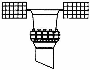
| Yantar 1K - 11,371 bytes. 366 x 265 pixels. |
|
Other Designations: Spin-2. Article Number: 11F660. Code Name: Kometa/Siluet. Class: Surveillance. Type: Military. Nation: USSR. Manufacturer: TsKB. The Yantar-1KF system was intended to build up high precision maps based on information from the Zenit-4MT. However it became impossible to keep the spacecraft within the weight that the Soyuz-U launch vehicle could lift. It would require a Proton or Zenit vehicle. Therefore the spacecraft was cancelled.
A complete design revision beginning in 1973 led to a production verion of the Yantar photo satellite for topographic mapping for the Army General Staff. The Yantar-1KFT is equipped with the TK-350 topographic camera, which has a focal length of 350 mm, with photo negative size of 300 x 450 mm, covering an area of 200 x 300 km with a resolution of 10 m and a scale of 1:660,000. The camera is designed for exceptional geometric precision for cartographic purposes and each image overlaps the next by 60% to 80% to allow stereoscopic pairs to be made. Closeup images are made by the KVR-1000 camera with a focal length of 1000 mm, a negative size of 180 x 180 mm covering an area of 40 km x 40 km at 1:50,000 scale and 2 m resolution. Western description: Fourth generation topographic. Typical orbital profile: inclination 64.9 degrees with an altitude of 207-270 km. Designed duration: 40 days. First flight: Cosmos 1246. Last flight: Cosmos 2284. Transmission frequencies observed in West: 150.3 PCM-FM; 400.8 CW.
SpecificationTotal Mass: 6,600 kg.
Yantar-1KFT Chronology
26 March 1971
Yantar-1FKT development authorised. Launch Vehicle: Soyuz 11A511. Central Committee of the Communist Party and Council of Soviet Ministers Decree 182-63 'On development of the Yantar-1KFT reconnaissance and cartographic satellite and the 11A511K launcher' was issued.
31 May 1976
Yantar-1KFT development approved. Decree 409-147 'On Creation of Yantar-1KFT Space Complex for Solving Goals of Cartography--development of the Yantar-1KFT reconnaissance satellite' was issued.
18 February 1981
Cosmos 1246 Launch Site: Baikonur . Launch Vehicle: Soyuz 11A511U. Mass: 6,600 kg. Perigee: 193 km. Apogee: 263 km. Inclination: 64.9 deg. Duration: 23.00 days. Military topographic / cartographic satellite.
28 May 1982
Cosmos 1370 Launch Site: Baikonur . Launch Vehicle: Soyuz 11A511U. Mass: 6,600 kg. Perigee: 195 km. Apogee: 273 km. Inclination: 64.9 deg. Duration: 44.00 days. Military topographic / cartographic satellite.
22 December 1983
Cosmos 1516 Launch Site: Baikonur . Launch Vehicle: Soyuz 11A511U. Mass: 6,600 kg. Perigee: 194 km. Apogee: 274 km. Inclination: 64.9 deg. Duration: 49.00 days. Military topographic / cartographic satellite.
14 November 1984
Cosmos 1608 Launch Site: Baikonur . Launch Vehicle: Soyuz 11A511U. Mass: 6,600 kg. Perigee: 195 km. Apogee: 248 km. Inclination: 70.0 deg. Duration: 33.00 days. Military topographic / cartographic satellite.
08 August 1985
Cosmos 1673 Launch Site: Baikonur . Launch Vehicle: Soyuz 11A511U. Mass: 6,600 kg. Perigee: 195 km. Apogee: 271 km. Inclination: 64.8 deg. Duration: 42.00 days. Military topographic / cartographic satellite.
06 October 1986
Cosmos 1784 Launch Site: Baikonur . Launch Vehicle: Soyuz 11A511U. Mass: 6,600 kg. Perigee: 190 km. Apogee: 283 km. Inclination: 64.8 deg. Duration: 36.00 days.
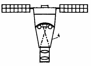
 | Yantar multi-return - Yantar bus reconnaissance satellite with multiple re-entry capsules. This is believed to be layout of Orlets-1. Orlets-2 must have a considerably extended bus to accomodate even more capsules. 12,491 bytes. 344 x 268 pixels. |
Military topographic / cartographic satellite.
08 July 1987
Cosmos 1865 Launch Site: Baikonur . Launch Vehicle: Soyuz 11A511U. Mass: 6,600 kg. Perigee: 192 km. Apogee: 297 km. Inclination: 64.8 deg. Duration: 37.00 days. Military topographic / cartographic satellite.
14 November 1987
Cosmos 1896 Launch Site: Baikonur . Launch Vehicle: Soyuz 11A511U. Mass: 6,600 kg. Perigee: 206 km. Apogee: 263 km. Inclination: 64.8 deg. Duration: 41.00 days. Military topographic / cartographic satellite.
18 May 1988
Cosmos 1944 Launch Site: Baikonur . Launch Vehicle: Soyuz 11A511U. Mass: 6,600 kg. Perigee: 196 km. Apogee: 288 km. Inclination: 64.8 deg. Duration: 36.00 days. Military topographic / cartographic satellite.
29 December 1988
Cosmos 1986 Launch Site: Baikonur . Launch Vehicle: Soyuz 11A511U. Mass: 6,600 kg. Perigee: 193 km. Apogee: 289 km. Inclination: 64.8 deg. Duration: 44.00 days. Topographic mapping for the Army General Staff.
24 May 1989
Cosmos 2021 Launch Site: Baikonur . Launch Vehicle: Soyuz 11A511U. Mass: 6,600 kg. Perigee: 204 km. Apogee: 280 km. Inclination: 69.9 deg. Duration: 43.00 days. Topographic mapping for the Army General Staff.
15 May 1990
Cosmos 2078 Launch Site: Baikonur . Launch Vehicle: Soyuz 11A511U. Mass: 6,600 kg. Perigee: 196 km. Apogee: 280 km. Inclination: 70.0 deg. Duration: 44.00 days. Topographic mapping for the Army General Staff.
15 February 1991
Cosmos 2134 Launch Site: Baikonur . Launch Vehicle: Soyuz 11A511U. Mass: 6,600 kg. Perigee: 190 km. Apogee: 306 km. Inclination: 64.7 deg. Duration: 45.00 days. Topographic mapping for the Army General Staff.
17 December 1991
Cosmos 2174 Launch Site: Baikonur . Launch Vehicle: Soyuz 11A511U. Mass: 6,600 kg. Perigee: 193 km. Apogee: 306 km. Inclination: 64.9 deg. Duration: 44.00 days. Topographic mapping for the Army General Staff.
29 April 1992
Cosmos 2185 Launch Site: Baikonur . Launch Vehicle: Soyuz 11A511U. Mass: 6,600 kg. Perigee: 209 km. Apogee: 274 km. Inclination: 70.0 deg. Duration: 43.00 days. Topographic mapping for the Army General Staff.
27 April 1993
Cosmos 2243 Launch Site: Baikonur . Launch Vehicle: Soyuz 11A511U. Mass: 6,600 kg. Perigee: 189 km. Apogee: 233 km. Inclination: 70.4 deg. Duration: 9.00 days. Topographic mapping for the Army General Staff. Mission normally would have run 44 days.
29 July 1994
Cosmos 2284 Launch Site: Baikonur . Launch Vehicle: Soyuz 11A511U. Mass: 6,600 kg. Duration: 44.00 days. Topographic mapping for the Army General Staff. Landed September 11 1994.
14 May 1996
Kometa Launch Site: Baikonur . Launch Vehicle: Soyuz 11A511U. FAILURE: Upper stage failure. Mass: 6,600 kg. Topographic mapping satellite failed to reach orbit.
17 February 1998
Cosmos 2349 Launch Site: Baikonur . Launch Vehicle: Soyuz 11A511U. Mass: 6,600 kg. Perigee: 212 km. Apogee: 327 km. Inclination: 70.4 deg. Duration: 44.00 days. Topographic mapping for the Army General Staff. Landed in Kazakhstan April 2 1998.
29 September 2000
Cosmos 2373 Launch Site: Baikonur . Launch Vehicle: Soyuz 11A511U. Twentieth Kometa cartographic satellite, using the Yantar service module with a Vostok-type reentry vehicle. It was announced as a dual civil-military geodetic mission. After a day it raised its orbit to 211 x 285 km x 70.4 deg. Landed in Russia November 14.
Bibliography:- 101 - Novosti Kosmonavtiki, "Neudachniy pusk KA 'Kometa'", 1996, Issue 6, page 32.
- 102 - Voevodin, Sergey A, VSA072 - Space Apparatus, "Sergey A. Voevodin's Reports", . HTML when accessed: http://www.mcs.net/~rusaerog/sergeyv/VSA.html
- 110 - Grahn, Sven, Sven Grahn's Space History Pages, . HTML when accessed: http://www.users.wineasy.se/svengrahn/
- 445 - Melnik, T G, Voenno-Kosmicheskiy Siliy, Nauka, Moscow, 1997..
Back to Index
Last update 12 March 2001.
Contact Mark Wade with any corrections or comments.
Conditions for use of drawings, pictures, or other materials from this site..
© Mark Wade, 2001 .