Credit: NASA. 21,732 bytes. 323 x 309 pixels.
| astronautix.com | SECOR |
|
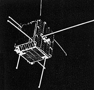
| SECOR - Credit: NASA. 21,732 bytes. 323 x 309 pixels. |
Small geodetic spacecraft used to precisely determine points on the earth (notably islands in the Pacific). Geodetic SECOR (Sequential Collation of Range) was an all-weather geodetic survey system which was in operational use for over 3 years, establishing a global survey network. It used the successive positions of artificial satellites in space to determine locations on the earth's surface with exactness over long distances. The system consisted of a satellite and 4 ground stations. 3 at geographical points where the co-ordinates had been surveyed accurately and the fourth at an unknown location. Radio waves were flashed from the ground stations to the satellite and returned. The position of the satellite at any time was fixed by the measured ranges from the 3 known stations. Using these precisely established satellite positions as a base, ranges from the satellite to the unknown station were used to compute the position of the unknown station. Geodetic SECOR allows continents and islands to be brought within the same geodetic global grid. Each ground station was entirely portable and contained 3 units: a radio frequency shelter, a data handling shelter and a storage shelter. Lighter weight, solid-state equipment was developed to replace the initial units. The satellite had a mass of 18 kg and contained a transponder, a telemetry system to monitor temperature and operating voltages, and a power unit comprised of solar panels and batteries. Prime Contractor was Cubic Corporation. Experiments with SECOR led to Timation, and finally the GPS Navstar system. 18
Located Pacific islands. Space craft engaged in investigation of spaceflight techniques and technology (US Cat A).
Space craft engaged in investigation of spaceflight techniques and technology (US Cat A).
Failed. Space craft engaged in investigation of spaceflight techniques and technology (US Cat A).
Failed. Space craft engaged in investigation of spaceflight techniques and technology (US Cat A).
Spacecraft engaged in research and exploration of the upper atmosphere or outer space (US Cat B).
Space craft engaged in investigation of spaceflight techniques and technology (US Cat A).
Space craft engaged in investigation of spaceflight techniques and technology (US Cat A).
Space craft engaged in investigation of spaceflight techniques and technology (US Cat A).
Location survey. Space craft engaged in investigation of spaceflight techniques and technology (US Cat A).
Spacecraft engaged in practical applications and uses of space technology such as weather or communication (US Cat C).